| Week
Twenty Two: The Presidentials, improbable meetings, and on into Maine
Sunday
September 4th, 1983
I hiked quite a respectable day. Got up at 5:30 am, hiked till 6:15
pm, and covered fifteen miles. This does not sound like much after
reading about twenty and twenty-five mile days, but fifteen in the
Whites is not to be scoffed at due to the fact that this is some
of the toughest terrain on the whole of the Appalachian Trail. Oh,
and yes, I had seen the "This area has the worst weather in
the world" sign as I prepared to rise above treeline. I had
seen it many times before - many times, but it was usually coated
in ice and snow and quite unreadable. Today it was very legible,
so I knew I had nothing to worry about.
In this section I passed two huts, and each is supposed to be a
day's hike between them for average hikers. Every time I'd hit a
hut I'd pig out on leftovers, and on top of Mount Washington I ate
at the cafeteria. I had three ice cream sandwiches and two Pepsi's,
but at the huts I ate nutritious hut food. The traverse over the
Presidential Range was full of people peak bagging, but by early
evening they had all gotten either down below tree line, or into
a hut. I thought that ridge runners would clear the trail above
treeline, but such was not the case at Edmonds Col. I was counting
on the fact that being half way between Mt Washington Observatory
and Madison Hut I would be in a remote enough spot to stave off
the advances of those who would kick me off this part of the traverse.
Just in case they were glassing the top I did not erect my tent
until after dark.
I have
elected to stay in a secluded spot, at Edmonds Col, which is two
miles shy of Madison Hut, because I'm sure that the hut is full.
Stealth camping, here I'm well above tree line which is very dangerous
in bad weather, but I checked the weather forecast while at Mt.
Washington Observatory and they called for a perfectly clear night
as well as a perfect day tomorrow - so I'm giving it a shot.
The
Milky Way is simply magnificent from this perch and I have never
seen it with such clarity as I have here. Because of light pollution
back home I just can't see the detail and sheer majesty of our galaxy
with such detail and depth as I can in these mountains. A feeling
of diminutive stature and utter non-relevance began to envelope
me here. Humbled by its enormity and complexity, I watched the succession
of nebulae perform their march through the evening sky. I thought
to myself that my time here on this rock is so brief and inconsequential
compared to the billions of years that these giants have frolicked
amongst each other. I could not understand how anyone could believe
that all this was just for us - such a small, egocentric, and petty
way to view our place here.
Tomorrow
I will continue to Pinkham Notch AMC Hut.
-Rt302-webstercliffs-t.jpg) (Route 302 from
Webster Cliffs)
(Route 302 from
Webster Cliffs) -Willard-f-webster-tn.jpg) (Willard Mtn. from
Webster Cliffs)
(Willard Mtn. from
Webster Cliffs) -Eisenhower-fClinton-t.jpg) (Mt. Eisenhower
and Washington from Mt. Clinton)
(Mt. Eisenhower
and Washington from Mt. Clinton)
-Washf-lakeclouds-tn.jpg) (Mt. Washington
from Lake of the Clouds Hut)
(Mt. Washington
from Lake of the Clouds Hut) -LakeClouds-Hut-tn.jpg) (Lake of the Clouds
Hut)
(Lake of the Clouds
Hut) -f-wash-tn.jpg) (From Washington
back to Lake of the Clouds)
(From Washington
back to Lake of the Clouds)
-ClayJeff%20Adams-tn.jpg) (Northern Presidentials:
Clay, Jefferson and Adams)
(Northern Presidentials:
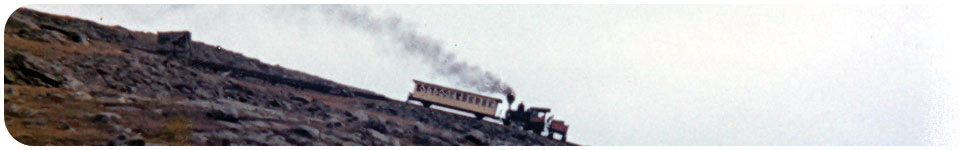
Clay, Jefferson and Adams) -Cog-Railway-tn.jpg) (Cog Railway on
Washinton)
(Cog Railway on
Washinton) -washfmontlawn-tn.jpg) (Mt Washington
from Monticello Lawn)
(Mt Washington
from Monticello Lawn)
-adams-jeff-tn.jpg) (Mt Adams from
Mt Jefferson)
(Mt Adams from
Mt Jefferson)
Monday
September 5th, 1983
Obviously if you are reading this, you know that I survived the
above tree line camp last night. As a matter of fact it was a bit
on the warm side even though the wind did blow at a constant velocity
all night.
Most of the day was uneventful. I hiked over to Madison Hut and
was treated to a free omelet courtesy of the hut croo. The omelet
was a leftover; perhaps they made too many. From there I hiked down
to Pinkham Notch AMC Hut where I bought and ate a trail lunch for
$2.00. I took advantage of the showers there; bathed myself, and
washed my shorts and shirt by hand in the sink. I talked to a few
people around the building before departing and hiking 1.9 miles
up Wildcat Trail. At that point I found a nice place to camp - complete
with a spring! How lucky I was to be all alone on the entire traverse
of the Presidential Range which made it all the more special - just
me and my thoughts.
I had
been up Wildcat via that trail twice in the past that I remember,
and both times in the winter. I knew that it would be a climb rather
than a hike from experience. During the winter it is necessary to
climb it wearing crampons. Being fairly intimate with this climb
I also knew that there was a very small camping spot tucked behind
one of the boulders halfway up the worst of the ascents. I figured
that if I got tired I could set up a bivouac there even though I
hadn't seen anyone camp in this spot before. I was pretty certain
that few knew about it because there was no trash there and the
moss had not been flattened or even been disturbed. As it turned
out I was fit enough to get to the hut with ease, but chose to settle
in and enjoy the solitude. In the past three days I think I have
seen more people than on the entire trip. The Mount Washington Observatory
was packed as well as all the huts that I passed. Plus, there were
people all over the ridges. The only time I had the mountains to
myself was early this morning, and unfortunately that didn't last
very long.
A few days ago I bitched at the hut people. Well I take it back
- they're OK and I have been treated pretty well. Oh yeah, I hiked
about 11.0 miles today.
-Thunderstorm-Junc-tn.jpg)
-Thunderstorm-Junc2-tn.jpg)
-Thunderstorm-Junc3-tn.jpg) (Three
views near Thunderstorm Junction)
(Three
views near Thunderstorm Junction) -Airline-Trail-tn.jpg) (The
Airline Trail)
(The
Airline Trail)
-Madison-Springs-tn.jpg)
-Madison-Springs2-tn.jpg) (Madison Springs
Hut)
(Madison Springs
Hut)
Tuesday
September 6th, 1983
A strange chain of events lead to a bizarre meeting today. I got
up at 5:50 am feeling quite tired and drained. My body was telling
me that it needed a rest. I had a headache, but had no aspirin left.
By the time that I got to Carter Notch Hut I was pretty tired. It
is now after Labor Day, and the hut was relatively empty. Today
was the first day of caretaker service at the huts, which meant
that it would cost only $6.00 to stay as opposed to the $26.00 that
the weekend warriors have to pay during the summer months. With
all of these things considered, I decided to take the day off and
rest. I hung around, slept and read all afternoon. At about 3:00
pm, I was sitting out in front of the bunkhouse when I heard a noise.
I turned around to see Jim Moore walking up the trail toward me.
If you recall at the beginning of this journal, he was the guy that
Dia and I hiked up the approach trail to Springer Mountain with.
What are the chances of me meeting him now?
Jim
had taken a carpentry job here in NH and when asked by his boss
if he would like to hike for the weekend he had jumped at the opportunity.
They had hiked up the Greenleaf trail which is not steep but long.
His boss was bragging to Jim about how the flatlanders couldn't
handle the trails in NH but the NH residents were tough and could.
Well Jim had left him in the dust and he had gotten to the hut well
before him so when I caught wind of the braggart and that Jim had
beat him to the hut I decided to go down and feed him a bit of humble
pie. I quickly ran down the trail until I found him sitting on a
rock, panting. I told him that I had come to help and promptly relieved
him of his pack and ran back up to the hut. About a half hour had
lapsed before he got up to the hut and thanked me for helping. Sometime
later I told him that indeed I was one of those flatlanders coming
from a state whose highest elevation was only slightly higher than
the mound of trash in the Central landfill in my state. We all got
to know one another and had a good time. I still can't get over
the coincidence. Very strange!!!
Tomorrow I'm back on the trail to Katahdin (The big "K").
Robert and Janet, who are day-hiking this section, found out from
Jim that I was at the hut and stopped in to say "hi" before
continuing on.
Wednesday
September 7th, 1983
The normal croo had left the hut to a caretaker who would man the
hut until closing which meant no elaborate breakfast meal to mooch
this morning. I said good-by to Jim and his friends and began the
climb out of Carter Notch. Upon my arrival at the top of Carter
Dome, I took off my pack, sucked in a huge breath, and "rooster
crowed" down to the hut, where Jim answered with an owl hoot.
When we were together in Georgia one night we heard loud owl hoots
all night long, so perhaps he was reminiscing of the night that
we all spent together nearly two thousand miles before. I smiled
and laughed a little while still thinking about the coincidence,
then lifted my pack upon my shoulders and continued on. I was to
never see him again.
I had a black cloud follow me all the way to Imp Shelter. I ducked
inside the shelter just as it started to rain, but soon it stopped
and I continued northward on the trail.
I arrived at Rattle River Shelter about 4:00 pm and it is now about
7:00 pm now and no one else is here but me. I guess it's safe to
say that I will be staying here alone tonight. I am actually only
one and a half miles from US Rt. 2 which leads into Gorham, New
Hampshire, but rather than going into town this evening, I will
hit the grocery store one mile east of the A.T. tomorrow and move
on. A town stay is nice, but Mahoosuc Notch is within reach and
my feet are itching.
Felt like I had a pretty good day.
Thursday
September 8th, 1983
Within what seemed like only a few minutes, I had reached the highway
and had located the grocery store this morning. I restocked at the
store in a campground one mile east of the AT on US Rt. 2. I don't
recommend restocking there, and probably should have gone into Gorham
if I had know that. They didn't have shit there. I only chose to
resupply there because it was closest.
From Rattle Rive Shelter, I hiked fifteen miles today to Gentian
Pond Shelter. On my way out of the valley back into the mountains,
I did hang out at Wocket ledges for a while to rehydrate and munch
on trail mix. I felt at peace in this part of the world with vast
expanses of wilderness at my feet populated with a thick, lush,
hardwood and boreal forest that stretched out before me.
I caught up with Damien (Paul Nichols) again. Tonight I am staying
with some people who hiked Mahoosuc Notch recently, and they said
that we'll be lucky to hike ten miles a day through this section,
we'll see. They were not thru hikers and I scoffed in silence at
their prediction. By now I had taken with a grain of salt the predictions
of others as to the mileage that I could do. They had no idea what
shape I was in now. I must take into account the way my legs have
been feeling lately though, recently they always feel tired and
I don't know why. With only one more state to go and three miles
left in New Hampshire, I've come a long way!
-Androsoggin-tn.jpg) (Androscoggin
River from Wocket Ledges)
(Androscoggin
River from Wocket Ledges)
Friday
September 9th, 1983
Well, today was a big nine miler, but at least I'm in Maine now,
my last state. The guidebook also says that this is the hardest
section of the AT and I believe it and the hikers from last night
as well. I don't recall ever making note of the time of entering
any state, or even just the idea of passing into another state.
By now exact time was irrelevant. All I needed to know was what
part of the day it was, whether it be morning or early afternoon,
or even late afternoon. These were the only approximations that
I needed to conduct my life out here. It was nice to arrive at a
destination, but not as crucial as knowing all that I needed to
survive was coming along with me. I did not carry a watch on my
wrist, but only had an alarm clock/radio buried somewhere deep in
the recesses of my backpack. The only thing that kept me in temporal
lock step with the rest of the world was this log book. Each day
I would enter into my journal an account of my journey and in turn
each day this book would remind me of how the world outside of nature
was moving at a different pace than me.
I had
no idea what was in Maine when I reached its border and this was
by design. At the onset of this journey I saw this as an adventure.
I had read a book about the nuts and bolts on how to prepare for
this trip, but that book only painted with a broad brush; describing
sections of this trail and this was all that I wanted to know. I
wanted to be surprised. This made the trip an adventure, so not
having knowledge was important to me. Recently, the section through
New Hampshire had been very familiar, but its beauty made up for
my intimate knowledge of the A.T. through this state. I wanted Maine
to be like the rest of the trip for me in that it would once again
become an unknown. Yes, of course I would peruse the next days hike,
but no more than that. I had planned where my mail drops would be,
but the miles between would remain an unknown by my footfalls until
trodden upon.
I am really looking forward to Mahoosuc Notch, one of the wonders
of Maine. I've been hearing about this place ever since Vermont.
Mahoosuc Arm, the climb out of the notch, is supposed to be real
tough also. Tomorrow I will hit both, and then it's on to Grafton
Notch. I have decided to resupply at Andover, Maine for I do not
have enough supplies to get to Stratton thanks to the poor grocery
at the campground I stopped at last.
I'm staying at Full Goose Shelter tonight with the crew from last
night plus Richard Kozon, who's been ahead of me from the beginning.
Richie was a fast hiker so I don't know how I caught up with him
this time. I remember Richie telling me long ago that he wanted
to learn to play the flute while hiking the trail, and planned to
practice after a full days hike. Holy crap where did he think that
he was going to Tanglewood? He had carried the instrument for a
long way before giving it up as a bad idea. Those damn things may
be small, but are heavy!! Come on Richie a little bit of reality
please!!
Beautiful day today - cool temperature, sunny and breezy. Couldn't
have it better!!
It's less 275 miles to the big "K".
I
encountered a Spruce Grouse along the footpath today. I couldn't
believe that I could get so close to a bird and not scare him away.
There he stood right in the middle of the trail with no apparent
worry that I would try to eat him. Even when I got to within a few
feet of him, he practically would not budge until the last minute.
He finally had to give trail, and then he only flew a few feet to
a low branch and looked at me. This was the first spruce grouse
that I had
ever seen.
-NH-MELine-tn.jpg) (Sign indicating
Maine State Line)
(Sign indicating
Maine State Line) -Grouse-nearline-tn.jpg) (Spruce Grouse
just past Maine State Line)
(Spruce Grouse
just past Maine State Line)
Saturday
September 10th, 1983
The Notch was cake; although, I did take a good spill. Hiking through
the Notch was the only time that I timed myself while hiking. Mainly
because I did not believe that I could be forced to a pace of only
one mile per hour, but it turned out that was the pace I maxed out
at. Regardless, it definitely was not as bad as the impression I
was left with by others telling me about it.
The
Notch is a narrow corridor between two mountains and inside are
huge boulders which have fallen into the "valley" making
it difficult to navigate. The majority of the rocks were very slippery
as most were covered with moss, which made the notch quite dangerous.
I "turtled" while trying to go up and over one of the
boulders instead of taking my pack off to go in between two of them.
It was damp, dank and dismal in the notch. There were huge crevasses
between some of the boulders which were ice filed, even at this
time of year that belched frigid air into the warm humid atmosphere.
While hiking through I occasionally could feel the frigid air blast
up from the recesses below as it flowed over my hot body. It was
as if the earth was breathing ice.
I stopped for a water and GORP break before hitting "The Arm".
The horrific, mind breaking climb out of "The Notch" that
was drummed into my head from weeks earlier never happened. Mahoosuc
Arm was much easier than I was told as well. Before long I topped
out, and followed around the shoreline of Speck Pond to the Speck
Pond Shelter arriving around 12:00 noon. I ate lunch at Speck shelter,
while watching a beaver swimming around in the pond, and having
a chat with the shelter girl who was up to her shins in shit - literally!
She trudged back and forth in her boots, wading in feces tediously
mixing it with hay to make compost before spreading it around the
area. This was one of her final duties before closing up camp for
the season. She said that someday she would like to hike the trail
too. Being a bit early still, I decided to move on to Grafton Notch
Lean to where I am now. There was a fire tower on Old Speck a short
distance past the shelter, but it was too socked in to bother to
go up. Paul and Rich got in to Grafton Notch about a half hour after
me.
The day was overcast and dreary. I am relieved that the day, and
this part of the trail is over.
Next
|
-Rt302-webstercliffs.jpg)
-Willard-f-webster.jpg)
-Eisenhower-fClinton.jpg)
-Washf-lakeclouds.jpg)
-LakeClouds-Hut.jpg)
-f-wash.jpg)
-ClayJeff%20Adams.jpg)
-Cog-Railway.jpg)
-washfmontlawn.jpg)
-adams-jeff.jpg)
-Thunderstorm-Junc.jpg)
-Thunderstorm-Junc2.jpg)
-Thunderstorm-Junc3.jpg)
-Airline-Trail.jpg)
-Madison-Springs.jpg)
-Madison-Springs2.jpg)
-Androsoggin.jpg)
-NH-MELine.jpg)
-Grouse-nearline.jpg)
